Royal Holloway Campus Map
Every Building, With Walking Times
All 64 buildings on the Egham campus pinned and searchable, from Founder's and McCrea to the Davison and the Sports Centre, with walking routes over the real footpaths. Works offline.
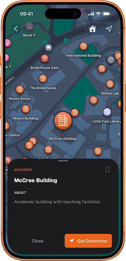
Every building on campus
Tap any building to open it in RHUL Mobile, where you get walking directions from wherever you are standing.
Loading the campus map
- Academic
- Halls
- Library
- Sport
- Theatre
- Worship
Academic37
- Arts AnnexeAnnexe to the Arts Building with additional teaching rooms.
- Arts BuildingHome to arts and humanities departments.
- Bedford BuildingHome to Computer Science, Mathematics, and Information Security departments. Features modern lecture theatres and computer labs.
- Bourne AnnexeAnnexe to the Bourne Building with teaching and laboratory space.
- Bourne BuildingScience and research building.
- Bowyer BuildingAdministrative offices.
- Computer CentreIT services and computer labs.
- Derbyshire BuildingAcademic building with teaching rooms.
- Electron Microscopy UnitSpecialist research facility with electron microscopes.
- Founder's BuildingThe iconic Grade I listed building and heart of Royal Holloway, featuring the Picture Gallery with Victorian art collection.
- GeochronologyEarth sciences geochronology research facility.
- Horton BuildingTeaching and research building.
- International BuildingSupport services for international students.
- Katherine Worth BuildingDrama and Theatre building.
- McCrea BuildingAcademic building with teaching facilities.
- Moore AnnexeAnnexe to the Moore Building with additional teaching and research space.
- Moore BuildingAcademic building near the library.
- Munro Fox Lab & Seminar RoomBiological sciences laboratory and seminar room.
- Munro Fox Lecture TheatreLarge lecture theatre for biology and life sciences.
- OmnidromeDrone research facility.
- Orchard BuildingTeaching and office building.
- Physics Department WorkshopWorkshop supporting the Physics department.
- Queen's BuildingMajor teaching building housing lecture theatres and seminar rooms.
- Shilling BuildingResearch and teaching facilities.
- Students' UnionStudents' Union building, home to Medicine bar and Tommy's Kitchen.
- Sutherland LodgeTeaching and research building.
- The BoilerhouseHistoric boiler house, now home to Electronic Engineering and the Boilerhouse Café.
- The ChestnutsAcademic and administrative building.
- The HubCentral student services building with café and study spaces.
- Tolansky LabPhysics research laboratory.
- Wetton's AnnexeAnnexe to Wetton's Terrace with offices and teaching rooms.
- Wetton's TerraceHistoric terrace housing administrative offices.
- Williams BuildingAcademic building on Founder's Square.
- Wilson LabResearch laboratory facility.
- Windsor BuildingAcademic building on Founder's Square.
- Wolfson LabResearch laboratory building.
- WoodlandsAcademic and office building near Founder's.
Halls11
- Bakeham HouseStudent accommodation south of campus.
- Butler HallStudent accommodation near The Hub.
- George Eliot HallsLarge student accommodation complex of lettered blocks.
- Gowar HallStudent accommodation on south campus near the sports centre.
- Highfield CourtModern student accommodation complex.
- iQ The PodiumPrivate student accommodation just 1-minute walk from Royal Holloway campus. Features studios and en-suite rooms with gym, games room, and study areas.
- Reid HallBlock 1 of Reid Hall.
- The PadPrivate student studios on Egham Hill.
- Tuke HallStudent accommodation near The Hub.
- Wedderburn HallStudent accommodation on south campus near the sports centre.
- Williamson HallStudent accommodation near The Hub.
Library4
- Emily Wilding Davison BuildingThe main university library with extensive study spaces, group rooms, and a comprehensive collection of academic resources.
- Founder's Reading RoomHistoric reading room and quiet study space in Founder's Building.
- Little Free LibraryCommunity book exchange on campus.
- Senate House Depository LibraryOff-site storage library facility.
Sport5
- Changing RoomsSports changing facilities.
- Eastfield PitchAmerican football and multi-purpose pitch.
- GymCampus fitness centre with weights and cardio equipment.
- Tennis CourtsTennis courts near Highfield Court.
- The Sports HallIndoor sports hall at the campus sports centre.
Theatre4
- Caryl Churchill TheatreMain theatre venue for drama performances.
- Handa Noh TheatreUnique Japanese-style Noh theatre, one of only a few outside Japan.
- Picture GalleryVictorian art gallery with works by Edwin Landseer and other 19th century artists.
- Shilling AuditoriumLecture auditorium in the Shilling Building.
Worship3
- Catholic Church of the Assumption of Our LadyRoman Catholic church on Harvest Road serving the university and local parish.
- College ChapelBeautiful Victorian chapel available for services and quiet reflection. Wheelchair accessible via ramp.
- Muslim Prayer RoomMuslim prayer facility on campus near Wetton's Terrace.
How the Royal Holloway campus is laid out
The Egham campus is 135 acres of parkland, and the buildings are not on a grid or named to any pattern you can guess from a room code. It divides into four rough clusters, which is the fastest way to build a mental model of it.
- Founder's and the historic core. The Grade I listed Founder's Building, opened by Queen Victoria in 1886, holds teaching rooms, the Picture Gallery, Founder's Dining Hall, Crosslands and the 24-hour Founder's Reading Room, as well as accommodation. It is the building on every photograph of the university.
- The academic cluster. Bedford, McCrea, Moore, Bourne, Queen's, Horton, Arts, Windsor, Shilling, the International Building and the Computer Centre sit within a few minutes' walk of each other, which is where most timetabled teaching happens.
- The Emily Wilding Davison Building. The library, student services and the 24-hour reading room, and the building behind every room code starting "EWD".
- The north side. The Sports Centre, gym, sports hall, tennis courts and outdoor pitches, plus the halls that sit out towards the edge of the grounds.
Most building-to-building walks inside the academic cluster are 3 to 7 minutes. End to end, Founder's to the Sports Centre is about 12 to 15 minutes. The map gives you the real number from where you are standing rather than a straight line across the lawn.
Decoding Royal Holloway room codes
Room codes name the building first, so the prefix is the only part you need in order to know where to walk. "EWD-1-04" is the Emily Wilding Davison Building, floor 1, room 04. Search the building, walk to the door, then find the room inside. The timetable guide covers the common prefixes, and the first week guide covers the rest of the admin that lands alongside your first timetable.
How it works
Up and running in seconds.
Search any building
Type a building name or browse the map.
Get walking directions
Routes follow the real campus footpaths and show the walk time.
Arrive on time
Follow the route from where you're standing now.
Why people use it
Every academic building
Every academic building has a labelled pin, including Founder's, Bedford and the Emily Wilding Davison Building's 24/7 reading room.
Every residence hall
Every hall is on the map with its main entrance pinned, including Founder's, Reid, Runnymede and Highfield Court.
Real walking routes
Directions follow the actual footpaths and roads on campus rather than straight lines through buildings.
Works completely offline
The map and walking routes are stored on your device, so building locations, directions and GPS all keep working without an internet connection.
Uses your live GPS location
Tap any building and the route starts from wherever you actually are, not from the campus centre.
Off-campus too
Places further than 5km from campus hand off to your device's default maps app instead of trying to route across the M25.
What people say
"Spent half of freshers week lost trying to find McCrea. Wish I had this app then."
"The map helped me find the music practice rooms which are literally hidden."
"No more wandering round at 8am trying to work out which building my lecture's in."
"Gave my phone to a visiting friend and they found their way around campus on their own."
Frequently asked questions
Which buildings can I find on the Royal Holloway campus map?
Every public building on campus. Founder's Building (Grade I listed, opened by Queen Victoria in 1886, home to the Picture Gallery and Founder's Dining Hall), the Bedford Building (Engineering, Physical and Mathematical Sciences), the Emily Wilding Davison Building (library, student services, 24/7 reading room), McCrea, Moore, Bourne, the Arts Building, the Hub, the Chapel, the Sports Centre, the Students' Union building, the Health Centre, and every residence hall (Founder's, Reid, Runnymede, Gowar, Wedderburn, Penrose, Tuke, Butler, Williamson, George Eliot and Highfield Court). Smaller landmarks like the Picture Gallery and the music practice rooms are also pinned. Which hall is which, and how far each one is from teaching, is covered in the guide to Royal Holloway halls and student accommodation.
Does the campus map work offline?
Yes. The map and walking routes are stored on your device, so building locations and directions work without any internet connection. Your GPS position needs device location services enabled but does not need data. Anything that reads live information, such as laundry machines, events and news, does need a connection.
How long does it take to walk across the Royal Holloway campus?
The campus is 135 acres of parkland between Windsor and Heathrow. End-to-end (Founder's to the Sports Centre via Bedford and the Hub) is about 12 to 15 minutes at a normal pace. Most building-to-building walks in the academic cluster are 3 to 7 minutes. The app gives you the exact route and time from where you're standing. The Sports Centre end of that walk is covered in the Royal Holloway gym and sport guide.
Can I find specific rooms inside Royal Holloway buildings?
The map routes to a building entrance rather than navigating inside it, so search the building and walk the rest. Royal Holloway room codes name the building first - "EWD-1-04" is the Emily Wilding Davison Building, floor 1, room 04 - so the prefix is what you search for. The timetable guide decodes the common prefixes, and once you know the building the map gets you to the door.
Where are the Royal Holloway halls on the campus map?
All 11 residence halls are pinned with their main entrance rather than their postcode, which is the difference between arriving at the right door and walking the long way round a building on move-in day. That covers Butler Hall, Gowar Hall, Reid Hall, Tuke Hall, Wedderburn Hall, Williamson Hall, George Eliot Halls, Highfield Court, Bakeham House, The Pad and iQ The Podium, alongside the rooms inside Founder's itself. Tap any of them for a walking route from where you are standing, and see the halls and student accommodation guide for what each one is actually like.
Is the campus map official Royal Holloway?
No. RHUL Mobile is independent of Royal Holloway, built and run by SHACKSOLUTIONS LTD. The map data is OpenStreetMap (community-maintained, free to use), and the building positions and labels are manually curated against the official RHUL maps and verified on campus.